
Land Features
Kooweerup Swamp-- Early Descriptions
Some descriptions and records of the topography of the Clyde area at the time of the early settlers.
"Prominent Pioneer" Article by Thomas Patterson,
The greater part of Westernport was thickly timbered, and very wet; indeed Captain Wright in 1827 reported that “the sterile, swampy and impenetrable nature of the country surrounding Westernport Bay induced him to believe that it was unsuitable for colonisation.” A writer in the early station days alluded to it as “the fen country”, and a visitor in the winter once said, with pardonable hyperbole, it was “all a lake”.
But in the course of time the dying out of the timber and the draining of the land completely altered the character of the country, and the ameliorating effect of burning-off over large areas must be taken into account. For instance western end of the Koo-wee-rup or swamp was practically impenetrable till gradually opening up in this way.
On one occasion, at the close of a very hot day, a fire was daringly lit on the margin of the swamp. A favouring wind drove the flames on through the old-man tea-tree and tall and swaying reeds. The fire, with a very wide face, burned fiercely till after dark, when a great thunder-cloud came across from the north-west over the Dandenong Ranges, reflecting the glare from the fire and lighting up the whole country-side. It was a wonderful sight, so unusual that residents at a distance thought they saw an Aurora Australia. This fire, however, did an incalculable amount of good.
|
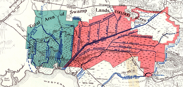
1920's Map of Clyde and the Kooweerup Swamp. Green area- Existing Cardinia Flood Protection District Red Area: Exisiting Kooweerup Flood Protection District. During 1865 some of the land bordering the Great Swamp became available and many Clyde families moved to take up land. James Lineham Peter Atkinson and W. E Manks, were a few of those to work at clearing their land of the dense ti-tree. Their difficulties increased by the severe flooding. Clyde Railway Station is marked on this map. Muddy Gates Lane is also seen in dark blue. Clyde Creek is shown linking into the draining system. |

| Hardships endured by early farmers Old Sherwood maps verify the location of these farms. Mr Tucker brother of Mr E J Tucker of Cranbourne wrote about himself and his brother William in October 1870. "Floods and disasters have occurred all over the country and
William's selection and my [own] being part and on the borders of the great Kooweerup Swamp it was flooded so that his cattle had to wade belly deep to get at the grass-the consequence of which is that his stock did very badly and are now in low condition. |
 |
Bridges and roads were washed away, crops rotted and stock loosse were high with oveer 8,000 cattle lost. Many were washed out to sea to return several times with the tides. Trains were halted and the only way out was by boat or to walk along the railway track. Final Solution 1938 See under Clyde Creek the comment made by Eric Thomas about the impact of the Swamp in the Clyde at the time of the 1934 floods, The Koo-Wee-Rup Swamp was a large freshwater swamp located to the south east of Melbourne, Victoria. It was drained an area of West Gippsland, with several waterways including Cardinia Creek and the Bunyip River |
Source
1. Wikipedia http://en.wikipedia.org/wiki/Koo-Wee-Rup_Swamp
2. The Good Country p 110
3. Kooweerup Swamp Drainage area 1920's Map : State Library of Victoria
Title: Plan showing flood protection and drainage works for Cardinia and Kooweerup Swamp lands
4. Thomas Patterson Australiasian Post December 24, 1932
5. Look to the Rising Sun- A History of Cardinia and District