
Clyde and Cardinia Creeks
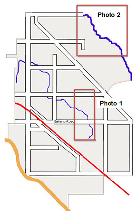
| Clyde Creek The Clyde Creek begins somewhere on the west side of where Hardys Road meets Clyde-Berwick Road and continues across Patterson Road, Tuckers Road over Ballarto Road and joins up with the drain that takes its waters into Westernport Bay near Tooradin. It was an early natural boundary between Mayune and Garem Gam cattle runs before the land was surveyed. It was near this creek where James McKay carved the word "Clyde" onto a tree. The low lying wetland featured at "Cascades on Clyde" is near to the source of the Clyde Creek. Map at right shows the positions of Clyde Creek (thin blue line) and Cardinia Creek (top right). See the photographs below for more details |
 |
 |
Clyde Creek
This is an aerial photo taken January 1970 and shows the Clyde Creek.as the dark line running diagonally from left to right. Pattersons Road is from left to right at the top of the photo. At the bottom of the photo Ballarto Road is visible. Clyde Creek crosses Ballarto Road and appears to continue as a channel. The Clyde Creek formed the border of the Mayune and Garem Gam Runs.
|
| Clyde Creek and Flooding Eric Thomas, then a primary school boy, living on Ballarto Road recalls the following about this extraordinary flood. "December 1, 1934. A wet season with heavy rain through October to November and into December led to excessive flooding throughout the KooWeeRup Swamp due to a king tide in Western Port Bay. Water was over six feet deep in Koo-Wee-Rup town and all low lying areas were covered for a considerable time. Drainage works had been done for many years through the large Swamp with minimal results. |
At the time the Water Commission was working on a new drain to take the waters from Clyde Creek on a direct course to the Bay. They had come from the Bay to within about 20 feet of connecting with Clyde Creek when the flood came so the waters continued along the Creek down to add to the Swamp. The new drain came up through the Thomas farm to connect with the Creek just south of the Ballarto Road bridge. Read further the page about the Kooweerup Swamp |
Historically significant as this is where the Bunurong Tribe camped when moving districts in search of food.
It also served as a boundary marker for properties before the land was surveyed. Today it is the boundary between Casey and Cardinia shires.
http://vhd.heritage.vic.gov.au/#detail_places;63125
 |
Cardinia Creek This is the Cardinia Creek in its natural state, taken January 1972, at Clyde North/Officer. The creek meanders across the landscape. |
more>
Casey-Cardinia historian, Heather Arnold has further details about Creeks Creeks and Rivers on her blog site showing a 1970 aerial map of Clyde and Cardinia Creeks.
Sources
1. Creeks- Blog Links to our Past - Heather Arnold. "Creeks"
2. Photographs from the Casey Cardinia Library Corporation Archive
3. Eric Thomas, letter September 30, 2010